UK
Storm Ciaran: Major incident declared in England as 104mph winds batter Channel Islands and UK transport disrupted


Storm Ciaran has battered the Channel Islands with 104mph winds – while in parts of the UK a major incident has been declared with roads closed and ferry services cancelled.
The powerful storm swept in from the Atlantic over northwest France and the Channel Islands overnight, bringing with it powerful hurricane-force gusts and lashing rain.
In the Channel Islands, where a red weather warning is in place and a “major incident” has been declared, dozens of people have been forced to take refuge in a hotel after their homes were damaged by winds of over 100mph.
Three people have also been taken to hospital.
In the UK, the south of England is bearing the brunt, with a major incident in place for Hampshire and the Isle of Wight.
Follow live: Transport affected as storm approaches
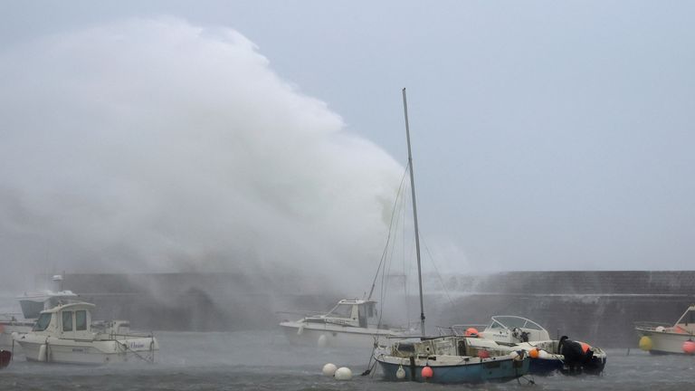
Waves crash over the harbour wall in Folkestone, Kent
Waves crash against the breakwater of the port at Goury near Cherbourg, France
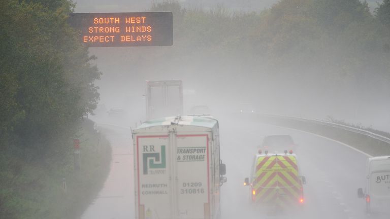
A weather warning sign alerts drivers travelling through water spray and winds on the M5 motorway
Hundreds of schools have closed in Southampton, the Isle of Wight and across Devon and Cornwall due to the storm on Thursday, while all schools have closed on the island of Jersey.
Cornwall Council says more than 10,000 homes in the county are without power due to the storm.
In France, at least one person has died. The man, a truck driver, was killed in the Aisne region, northeast of Paris, when a tree fell on his vehicle.
The country has seen record-breaking gusts of up to 119mph (193km/h) in the town of Plougonvelin, on Brittany’s western tip, according to France’s meteorological service, Meteo France.
Other observers, such as Meteociel, say they have recorded 128mph (207km/h) gusts at the coastal tip of Pointe du Raz, Brittany.
More than 1.2 million French households have been left without electricity because of the storm.
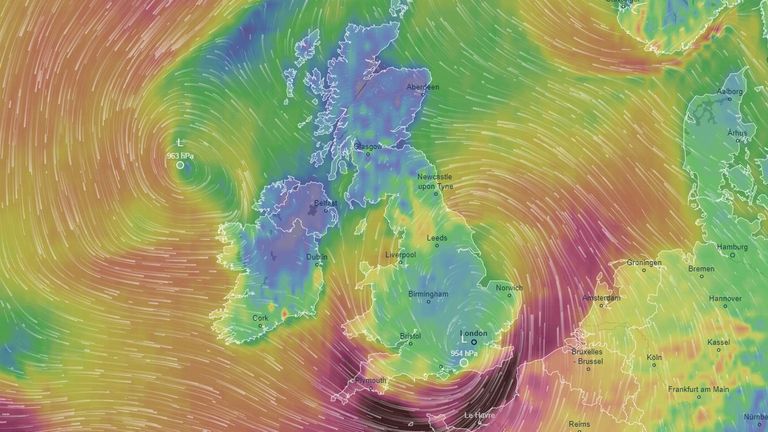
A weather map by Ventusky shows wind speeds with purple indicating speeds of more than 100km/h and dark purple in excess of 140km/h
Check the weather forecast in your area
In southern England, the storm has wreaked havoc on the transport network.
Commuters in southern England have been urged to work from home, with rail firms “strongly advising” passengers not to travel on routes in and out of London on Thursday morning, as they assess any fallen trees and debris on the line.
Several major bridges have been closed, including the M48 Severn Bridge, the Queen Elizabeth II Bridge near Dartford, The Sheppey and Medway crossings in Kent, the bridge over the River Hamble on the M27 and Southampton’s Itchen bridge.
A large number of ferry services have also been cancelled.
Condor Ferries cancelled its freight and passenger routes between the Channel Islands and the UK on Wednesday and Thursday, while DFDS and P&O Ferries have also suspended their services due to the high winds.
Jersey Airport, the main transport hub to the Channel Islands, has been closed today due to the storm, while in Europe, Dutch airline KLM scrapped all flights until the end of Thursday due to high winds in the Netherlands.
Weather warnings cover large parts of the UK
The Met Office has issued amber weather warnings for the South West and south coast of England for Thursday.
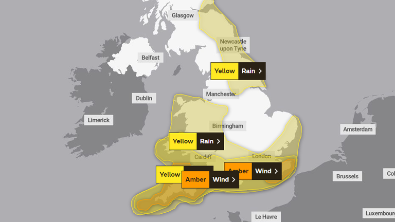
The Met Office’s latest weather warnings for Storm Ciaran (as of 8am on Thursday)
An amber alert for “very strong winds” and the potential for “large waves” is in place for parts of Devon and Cornwall until 11am today.
It warns of “flying debris” which “could result in a danger to life”, as well as the possibility of damage to buildings, and closures of roads, bridges and railway lines.
A similar warning is in place for parts of Kent and East Sussex until midday today, with the Met Office warning of wind speeds of up to 80mph in coastal areas and gusts of up to 85mph in exposed areas.
Overlapping yellow warnings for wind and rain, which cover the entire south of England, and parts of the Midlands and Wales, are also in place for both areas until midnight.
A separate yellow warning for rain is in place for the North East of England and eastern Scotland until 6am on Friday.
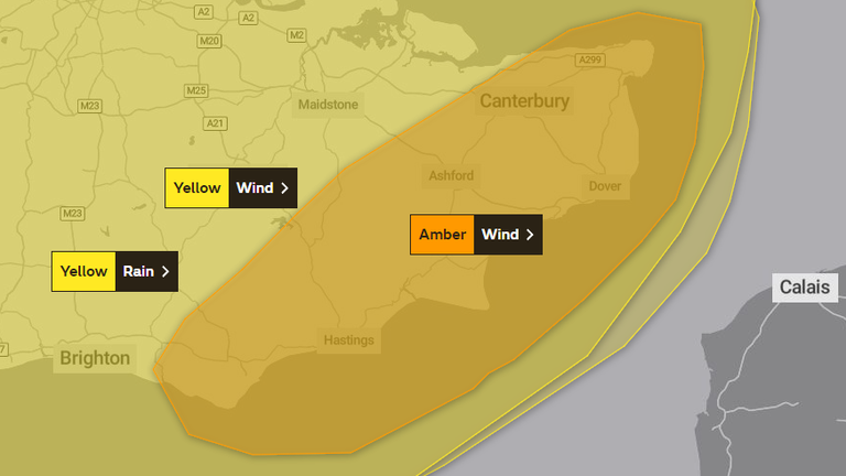
An amber alert for the South East of England is in place from the Met Office until midday Thursday due to Storm Ciaran.
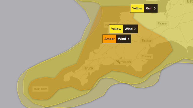
An amber alert is in place from the Met Office for Devon and Cornwall until 11am on Thursday.
As of 11am on Thursday, there were 77 flood warnings and 188 flood alerts across England.
Ben Lukey, flood duty manager at the Environment Agency, said parts of the south coast could see “significant flooding” on Thursday.
“Rain from the storm could also see significant surface water and river flooding across parts of the west, south and northeast of England from later today until Friday, with minor impacts possible more widely on Saturday due to further showers,” he said.
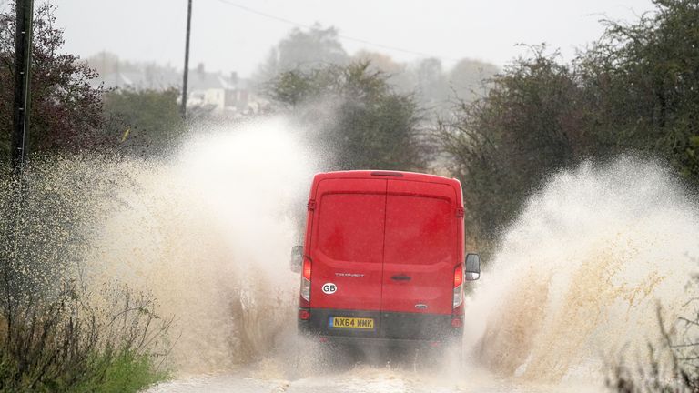
A van drives through flood water in Whitley Bay, north east England

Vehicles are driven through a flooded road in Yapton, West Sussex
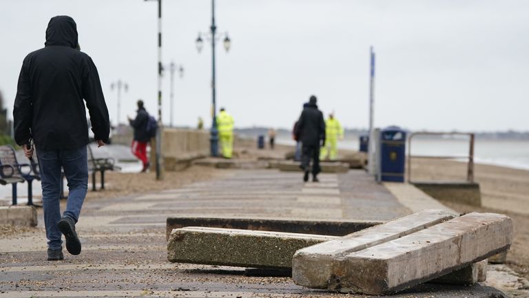
Concrete slabs displaced at Clarence Esplanade road in Southsea, Portsmouth

A trampoline on the railway tracks in St Austell
@networkrailwest
Read more:
‘Sting jet’ could bring winds like 1987 storm
Why Storm Ciaran will be so bad
Dangerous coasts and transport disruption
HM Coastguard has issued a warning for people to “stay away from the water’s edge” and to avoid the areas most likely to be impacted by Storm Ciaran.
National Rail is warning journeys could be impacted in Wales and the south of England by “heavy rain accompanied by strong winds” on Thursday, and across the northeast of England on Thursday and Friday.
The RAC has warned drivers in the south and west of the UK to avoid coastal and rural roads, due to reports of trees blocking several routes.
Meanwhile, the AA says its mechanics rang paramedics to help a driver suspected of suffering from hypothermia after their car became stuck in flood water on a rural road in the Newbury area.
The disruption follows flooding in Northern Ireland, with Newry in County Down badly hit overnight on Monday into Tuesday after the city’s canal burst its banks.
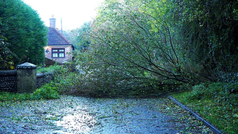
A fallen tree blocks a lane in Barnham, West Sussex
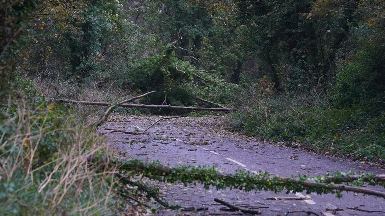
Trees and debris block the road in Dover, Kent
‘Wind damage’ and ‘a lot of rain’ likely
The Met Office, in its latest update, says Storm Ciaran will bring outbreaks of rain, some heavy, to most areas.
“This will be coupled with strong and gusty winds, potentially damaging across the southernmost parts of England. Northern Ireland should remain brighter, with isolated showers,” the Met Office said in its forecast.
“It will stay windy overnight with further outbreaks of rain developing in most areas, as a weakening Storm Ciaran remains close by, with some clear spells developing across the far south and west.”
Met Office meteorologist Clare Nasir said Storm Ciaran was “likely to be a notch down” in intensity from the recent Storm Babet, but flooding could still occur because the ground is “so laden with water” and river levels “are at their highest”.

Moment window is blown in by Storm Ciaran
Read more on Sky News:
Why Storm Babet brought so much rain
Police close beach after body found on shore
Rail ticket office closures cancelled after U-turn
Is Storm Ciaran affecting an area near you?
If you want to send photos or videos, you can email them to: news@skynews.com
If you want to send us pictures and video from your mobile phone use ‘Your Report’ on the Sky News app.
Or send us a message on WhatsApp.
By sending us your video footage/photographs/audio you agree we can broadcast, publish and edit the material and pass it on to others for similar use in any media worldwide, without any payment being due to you. Please do not submit your contribution unless you accept this.