UK
UK weather: Met Office raises impact level of heavy rain warning – days after Storm Ciaran caused chaos


The Met Office has raised the impact level of a warning for heavy rain across southern England – as nearly 200 flood alerts have been issued nationwide.
The yellow alert comes days after Storm Ciaran battered the same area with rain, flooding and winds of up to 100mph.
The weather service said already saturated conditions would increase the risk of flooding and travel disruption.
A large swathe of the South – from Dorset to Kent, and as far as south London – is covered by the warning from 5am on Saturday until midnight.
The warning is in force from 5am on Saturday until midnight. Pic: Met Office
Get the Sky News forecast for your area
The Met Office said it was raising the impact level of the weather warning to medium to cater for “higher rainfall totals in parts of the South East”.
The warning was updated on Saturday morning, removing it from southwestern parts of England where the Met Office said the heaviest rain has now passed.
It expected 15-25mm of rain to “fall quite widely”, especially towards the south coast, adding that the wettest spots in East Sussex and southeast Kent could receive 30-45mm of rainfall.
Spray and flooding could make car journeys tricky, and bus and train services could be affected too, according to the Met Office.
It also warned flooding of homes and businesses is possible as well as “a small chance of deep floodwater in places”.

The weather warning comes just days after Storm Ciaran hammered parts of the UK
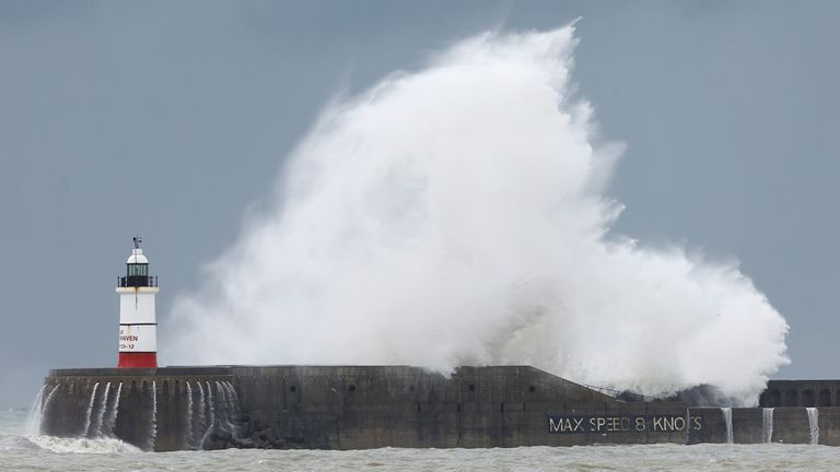
Newhaven harbour wall in East Sussex, pictured on Thursday
Met Office meteorologist Dan Stroud said this level of rain on its own would not usually be particularly concerning, but it came “against the backdrop of a very wet October and ongoing issues in parts of Sussex”.
He added: “It doesn’t actually take much more rain for there to be further impacts in relation to surface water issues on roads.”
The Met Office said the band of wet and windy weather will move north across much of England and Wales during Saturday with blustery heavy showers following.
Storm Ciaran was still causing some knock-on problems for the railways on Friday.
LNER, which runs the line between London King’s Cross and Edinburgh Waverley, advised passengers not to travel until Saturday.
Delays and cancellations were expected because trains and staff were out of position due to power failures.
Other operators also warned of disruption as they cleared debris off tracks.

A car struggles through a flooded road in Yapton, West Sussex, earlier this week

Flood warnings and alerts are also in place across the UK. Pic: Environment Agency
Storm Ciaran moved from the UK into the North Sea – and its southern edge caused chaos in parts of Italy.
Officials said six people died and two were missing after rivers in Tuscany burst their banks following torrential rain overnight into Friday.
There were fears Florence could be flooded, but the historic city avoided any major incidents.
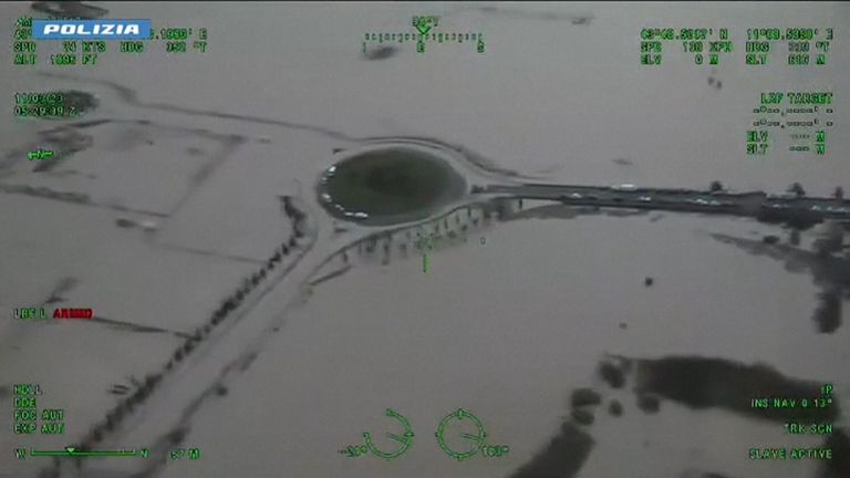
Tuscany hit by flooding after heavy rain
Italian Civil Protection officials said 200mm (7.87in) of rain fell in a three-hour period, stretching from Livorno on the western coast to the inland valley of Mugello.
Tuscany’s president, Eugenio Giani, said it had never had so much rain in such a short space of time.
He told Sky TG24 that experts believe it was the worst downpour in 100 years.
“What happened overnight in Tuscany has a clear name: CLIMATE CHANGE,” he wrote on X, formerly Twitter.