

UK weather: Schools closed and ‘danger to life’ warnings issued amid 70mph winds from Storm Babet

Some schools will close and people are being told to stay at home as Storm Babet bears down on parts of the UK.
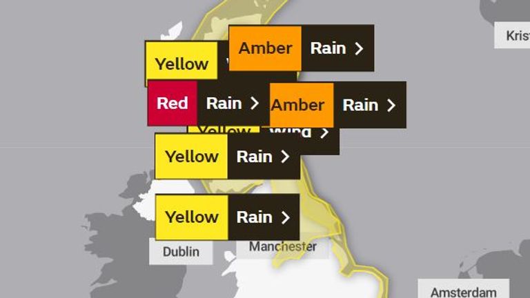
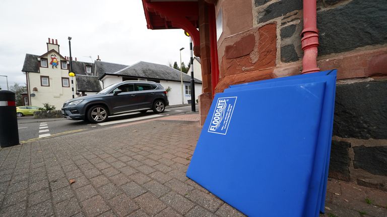
The Met Office has issued a rare red warning for “exceptional and persistent” rain in eastern Scotland, as well as amber and yellow warnings for wind and rain in other areas.
The red alert covers parts of the east of Scotland between the Dundee and Aberdeen areas from 6pm on Thursday until midday on Friday, “with some locations likely to see 200-250mm” of rainfall.
Check the weather forecast in your area
It marks the first time a red warning for rain has been issued in the UK since Storm Dennis in February 2020.
Storm Babet will be ‘unprecedented’
Babet, a complex area of low pressure that developed to the west of the Iberian Peninsula, will last until Saturday and is expected to cause flooding, power cuts and travel disruption.
Yellow severe weather warnings, meaning there is the threat of strong winds, extremely wet conditions and potential flooding, have been issued across the week until Saturday for a vast swathe of the UK, covering already-saturated parts of Scotland and northern and eastern England, all the way down the coast to Hampshire and the Isle of Wight.
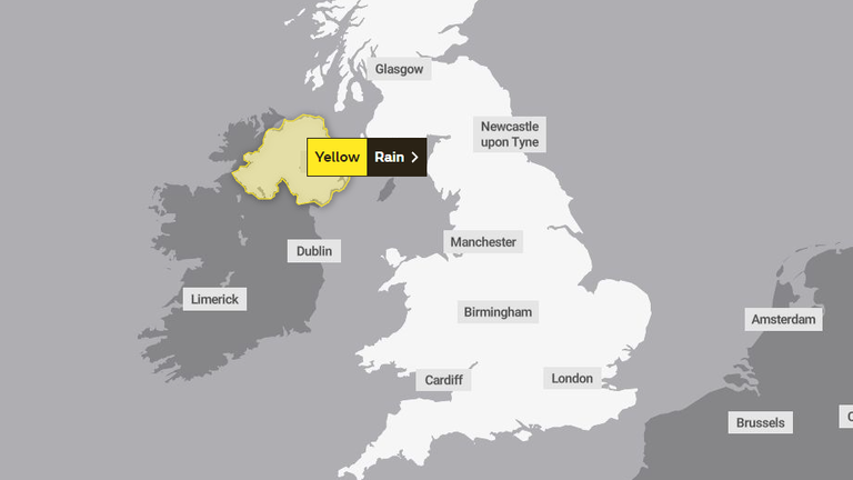
The Irish forecasting agency Met Eireann has also issued yellow and amber weather warnings for parts of Northern Ireland for heavy rain today and into Thursday.
On Tuesday, the Met Office raised the level of its warning for eastern Scotland from yellow to a more severe rating of amber.
A yellow weather warning covers Northern Ireland today. Pic: Met Office
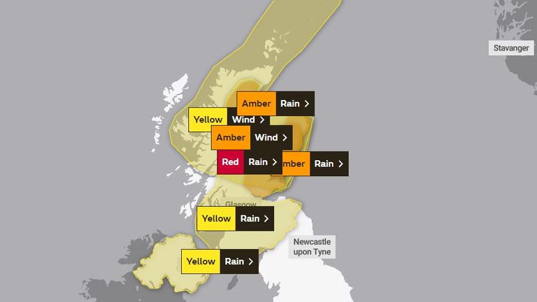
A red warning for rain is among the warnings in place on Thursday
The Met Office said people in Northern Ireland can expect spray and flooding which may lead to difficult driving conditions and some road closures for the duration of the yellow warning for rain. It comes into effect at 2pm today and expires at 10am on Thursday.
There is a “small chance” that homes and businesses could be flooded, causing damage to some buildings, and communities being cut off by flooded roads, forecasters warned.
Several warnings are in place for Friday
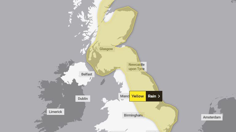
Much of Scotland and the east of England is under a yellow warning on Saturday. Pic: Met Office
As the rain moves northwards, it will stall across central and eastern parts of Scotland where the rain will become heavy and persistent from Thursday through to Saturday.
There is an amber severe weather warning for rain for this area, meaning exceptionally wet conditions are likely. Up to 150 to 200mm of rain could accumulate in some areas of higher ground.
‘Please stay at home’
Earlier on Wednesday, the Scottish Government held a meeting of its Resilience Room (SGoRR), in an effort to mitigate the affects of Storm Babet in the coming days.
In a statement, Deputy First Minister Shona Robinson said: “The strong message is that if you are in the parts of Angus and South Aberdeenshire affected – please stay at home and do not travel.
“Other parts of Scotland are also at risk of flooding as rivers respond and drainage systems become overwhelmed. The risk is exacerbated by the fact that many catchments are already saturated following last week’s heavy rainfall and flooding.
“No one should take the risks for granted and I would urge everyone in the country to prepare where necessary, heed the travel warnings issued by Police Scotland and take extreme care around fast-flowing water.”
In early October, up to 180mm (8in) of rain was forecast which led to landslides, train cancellations and sporting events being postponed due to floods.
In Angus, an area north of Dundee and up to the Cairngorms, schools will close at lunchtime on Thursday and into Friday, as the local council works to “preserve life”.
Residents in Aberfoyle, Perthshire, prepare for Babet
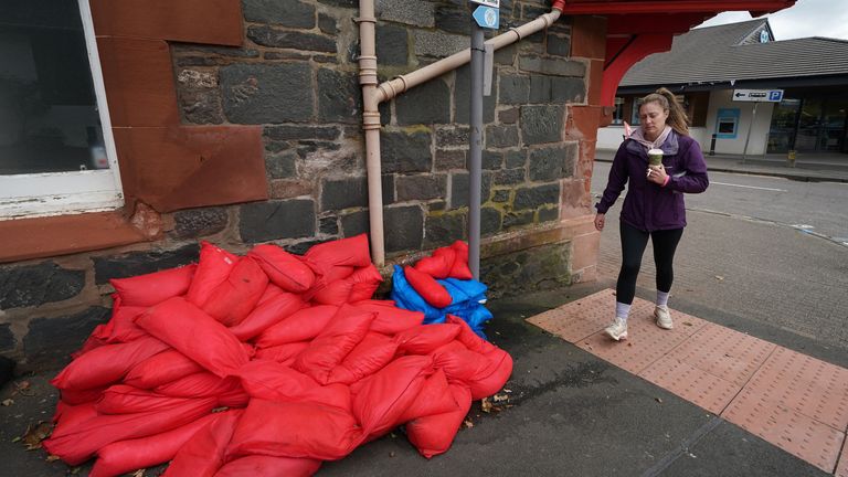
Residents in Aberfoyle, Perthshire, prepare for Babet
‘Danger to life’
Under the amber warning, the Met Office warns “extensive flooding to homes and businesses is possible, which could lead to collapsed or damaged buildings or structures” and “fast flowing or deep floodwater is likely, causing danger to life”.
“There is a chance that communities in flooded areas could be completely cut off, perhaps for several days,” it adds.
“Power and other essential services, such as gas, water or mobile phone service, may be lost.”
Scotland typically receives around 168mm of rainfall in October but the country will receive more than this amount in the span of a few days.
Parts of England can expect more than 100mm of rainfall during the week, with some isolated areas facing up to 150mm.
There are already mass train cancellations across Scotland, expected to last until Saturday, with services stopped from Aberdeen, Elgin, Edinburgh, Fife, Perth and beyond.
Read more from Sky News:
Teenager’s killer dies in prison
Captain Tom Foundation ‘to close down’
Ireland warned of ‘dangerous’ weather
Rain warnings for every county in the Republic of Ireland were in place overnight, having come into effect at various stages on Tuesday.
A Status Orange rain warning, meaning there is the possibility of dangerous or disruptive weather, is in place along Ireland’s southern coast for counties Cork, Kerry and Waterford.
That warning is due to the risk of flooding, dangerous road conditions and possible wave overtopping at high tide amid heavy rain and strong gusts.
The advisory is due to expire at 1pm, with a Status Yellow rain warning, meaning there is the potential for localised dangerous weather, in place for the rest of the country until between 6pm to 8pm.
Met Office deputy chief meteorologist Tony Wardle said: “Storm Babet will bring disruption for parts of the UK in the coming days, with heavy rain and strong winds likely for many.
“Heavy and persistent rain will fall onto already saturated ground bringing a risk of flooding. It is important to stay up to date with warnings from your local flood warning agency as well as the local authorities.
“As well as heavy rain, Storm Babet will bring some very strong winds and large waves near some eastern coasts too. Gusts around 70mph are possible in eastern and northern Scotland from Thursday. Met Office warnings will continue to be reviewed as the forecast develops.”


Wes Streeting has defended plans to make over 70s take compulsory eye tests every three years – which could see them banned from driving if they fail, it is understood.
Ministers are considering “tougher” measures to tackle road deaths and injuries in England and Wales, which they believe have “remained stubbornly high under successive Conservative governments”.
Under the new proposals, first reported by The Times, the drink-drive limit would be lowered to match the current rules in Scotland.
Currently, the drink-drive limit is 35 micrograms of alcohol per 100 millilitres of breath in England and Wales, or 80 milligrams of alcohol per 100 millilitres of blood.
But this is expected to be lowered to 22 micrograms of alcohol per 100 millilitres of breath or 50 milligrams of alcohol per 100 millilitres of blood, to match the stricter levels already enforced in Scotland.
Those caught not wearing a seatbelt could also receive penalty points for the first time, while drivers found on the road without insurance could also face more severe consequences.
As well as this, plans are currently being drawn up to make those aged 70 or over take a compulsory eye test every three years when they renew their driving licence.
Those who fail this would lose their right to drive under the proposals. It’s understood that tests for other conditions, such as dementia, are also being considered.
Speaking on Monday, Mr Streeting said the transport secretary is consulting and “considering a whole range of proposals”, which will be unveiled in the “not too distant future”.
It is understood that Heidi Alexander will unveil the measures in a new road safety strategy in the autumn.
Transport Secretary Heidi Alexander is expected to introduce the changes as part of the government’s road safety strategy in the autumn.
Pic: Reuters
The health secretary also defended the plans around elderly drivers.
He told broadcasters: “It cannot be right that we’ve ended up in a situation where the NHS is hit with a £2 billion a year bill because we are not taking road safety seriously enough – particularly as we get older and the quality of our eye health deteriorates, that we’re not keeping a regular check.”
Read more from Sky News:
The full-time workers who are turning to food banks
‘Deport now, appeal later’ scheme for foreign criminals expanded
A Labour source said: “At the end of the last Labour government, the number of people killed and seriously injured on our roads was at a record low, but numbers have remained stubbornly high under successive Conservative governments.
“In no other circumstance would we accept 1,600 people dying, with thousands more seriously injured, costing the NHS more than £2bn per year.
“This Labour government will deliver the first Road Safety Strategy in a decade, imposing tougher penalties on those breaking the law, protecting road users and restoring order to our roads.”
It comes after 1,633 people died in road traffic accidents in 2024, with nearly 28,000 victims seriously injured.


An amber heat health alert has been issued for large parts of England.
The amber alert – described as an “enhanced hot weather response” – covers East Midlands, West Midlands, East of England, London, and the South East.
The alert, issued by the UK Health Security Agency (UKHSA), is due to be in place from 9am on Tuesday, until 6pm on Wednesday.
Explainer: What is a heat-health alert?
The UK Health Security Agency (UKHSA) has issued alerts across England
The UKHSA, a government agency for England, warned “significant impacts are likely” across health and social care services due to the high temperatures.
Parts of the country are facing a fourth heatwave of the summer, where highs pass a threshold on three consecutive days.
A yellow alert, also between 9am on Tuesday until 6pm on Wednesday, covers the North East, North West, Yorkshire, The Humber, and the South West.
Check the weather forecast where you are
Dr Paul Coleman, consultant in public health at UKHSA, said temperatures are forecast to rise above 30C (86F) across some areas which “can result in serious health outcomes” particularly for the elderly or those with serious health conditions.
“If you have friends, family or neighbours who are vulnerable, it is important to ensure they are aware of the forecasts and are following the necessary advice.
“Check in on them if you can to make sure they know that hot weather is on the way and how to keep themselves safe,” Dr Coleman said.

Temperatures could peak in the low 30s on Tuesday, with a small chance of hitting 35C (95F)
Sky News meteorologist Christopher England said the high pressure that brought the warmth of the last few days via the “heat dome” effect is moving east, as low pressure moves in towards the west.
“On Tuesday, southern Britain can expect temperatures widely into the low 30s… perhaps exceeding 35C (95F) in places,” he said.

Drought in England explained
On 1 July, the UK recorded its hottest day of the year so far with a temperature of 34.7C (94.4F) recorded at St James’s Park in central London.
The Met Office’s criteria for a heatwave are met when temperatures are above a certain level for three consecutive days. This threshold varies from 25C to 28C (77F to 82F) depending on the location.

People enjoying the hot weather in North Shields in June. Pic: PA
Mr England added: “There’s around a 10% chance Wales may exceed its August peak temperature of 35.2C (95.3F) recorded at Hawarden on 2 August 1990.
“Expect some tropical nights too, with temperatures holding above 20C (68F).”
In July, the Met Office warned Britain’s climate is changing rapidly, with records regularly being smashed and extremes of heat and rainfall becoming the norm.
Read more from Sky News:
Tips for staying cool in bed
Could this be the UK’s hottest year?
How does sunscreen protect us?
The UKHSA has issued advice for keeping cool:
• close windows and curtains in rooms that face the sun
• seek shade and cover up outside
• use sunscreen, wear a hat and sunglasses
• keep out of the sun at the hottest times, between 11am and 3pm
• restrict physical activity to the cooler mornings or evenings
• know how to respond to heat exhaustion and heatstroke


Around 30 residents have been evacuated from their homes in north London after a water main burst, leaving roads under 44cm (17in) of water.
Seventy firefighters were dispatched by London Fire Brigade to the area around Canonbury Street in Islington just after 10pm on Sunday.
People have been urged to avoid the area including Essex Road, Elmore Street, Halliford Street and Ecclesbourne Road – and warned against driving through floodwater.
Canonbury Street in Islington experienced significant flooding. Pic: London Fire Brigade
Fire crews used flood barriers and sandbags to divert floodwater away from homes as they warned disruption was likely to continue into Monday afternoon.
Islington council also warned at 9am on Monday that Canonbury Street was closed from Essex Road up to Arran Walk.
A Thames Water spokesperson said: “We have now managed to stop the flow of water and ensure that the site is safe. We have also been able to move parked cars which were over another critical water main.
“We have a specialist team on site for those impacted by the incident, at Cedar Place on Essex Road, and are supporting customers who have been affected.
“To keep the public and our team safe, we’ve arranged equipment to help manage the traffic while we work in the road. We are sorry for the impact this may have on traffic in the area.”
-
 Sports3 years ago
‘Storybook stuff’: Inside the night Bryce Harper sent the Phillies to the World Series
-
 Sports1 year ago
Story injured on diving stop, exits Red Sox game
-
 Sports2 years ago
Game 1 of WS least-watched in recorded history
-
 Sports2 years ago
MLB Rank 2023: Ranking baseball’s top 100 players
-
Sports4 years ago
Team Europe easily wins 4th straight Laver Cup
-
 Sports2 years ago
Button battles heat exhaustion in NASCAR debut
-
 Environment2 years ago
Japan and South Korea have a lot at stake in a free and open South China Sea
-
 Environment2 years ago
Game-changing Lectric XPedition launched as affordable electric cargo bike