

UK weather: Storm Babet batters large parts of country – as second person confirmed dead in Scotland
A second person has died as Storm Babet batters large parts of the UK.
Police Scotland said a 56-year-old driver was killed after a tree struck a van on the B9127 at Whigstreet near Forfar at around 5.05pm on Thursday.
It comes as a rare red weather alert issued by the Met Office, warning of a “danger to life from fast flowing or deep floodwater” in parts of Scotland, was extended until midnight on Saturday.
It now covers the Grampian and Central, Tayside and Fife regions. It had already been expanded to include Dundee, Perth and Kinross, as well as Angus and Aberdeenshire, where 20ft waves have been spotted on the coastline.
Storm Babet latest: ‘Serious emergency’ declared by Scottish council
Meanwhile, a major search was under way following reports of a man trapped in a vehicle in floodwater.
Police Scotland said the alarm was raised at 3am on Friday near the village of Marykirk in Aberdeenshire.
“Multi-agency searches are ongoing and the public are asked to avoid the area for their safety,” a force spokesperson said.
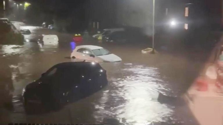
As England, Wales and Northern Ireland faced warnings about heavy rain, Scotland continued to bear the brunt, where emergency crews have also been trying to rescue people in Brechin.
The town has been the hardest hit by the unprecedented flooding – and there are fears people who have had to flee their homes may not be able to re-enter until after Christmas.
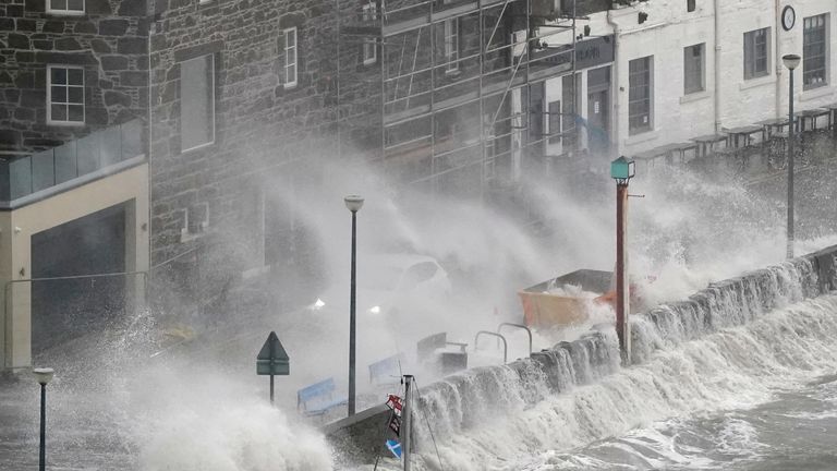
Waves at Stonehaven Harbour
The Met Office said some communities could be cut off for several days at least by severe flooding, while the British Geological Survey has warned the storm could also cause landslides in Scotland.
The Scottish Environment Protection Agency (SEPA) has five severe flood warnings, 11 flood alerts and 16 flood warnings in place, with the threat of “unprecedented” levels of rainfall in the northeast of Scotland.
It has warned rivers could rise by as much as five metres, in what has been described as an “extraordinary” weather event.
SEPA flood duty manager Pascal Lardet said: “There is exceptional rainfall forecast for parts of Scotland over the next 24 hours, and this will lead to significant flooding from both surface water and rivers.”
Check what the weather forecast is in your area
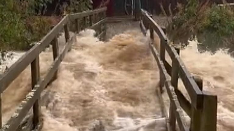
Bridge submerged in Scotland
‘People may not be back in their homes by Christmas’
It comes after a woman died in Scotland when she was swept into a river amid gale-force winds and severe flooding.
The body of the 57-year-old has been recovered after she was swept into the Water of Lee, a river in the eastern area of Angus on Thursday.
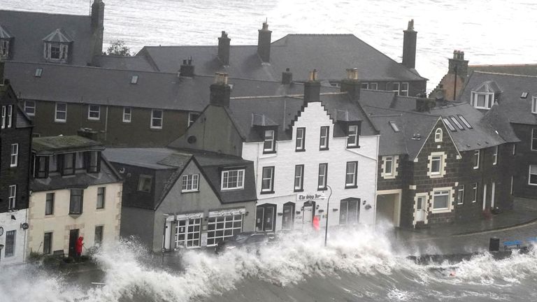
Officials have ordered the evacuation of 400 homes in and around the town of Brechin where flood defences breached.
Angus Council, which serves the town near the eastern Scottish coast, said parts of Brechin are only accessible by boat and added: “Angus is in the middle of a very serious emergency. Flooding is unprecedented. Levels are over half a metre over the last highest ever.”
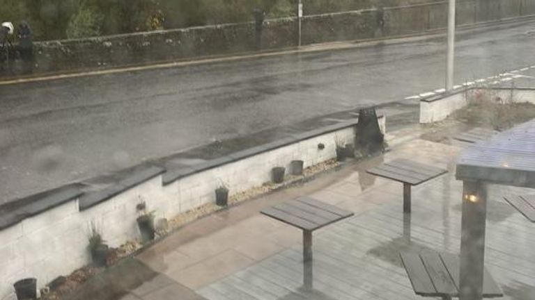
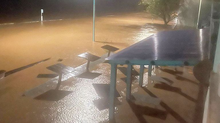
This image shows a road before the River Esk burst its banks in Brechin – with the photo below showing the impact of the flooding
It said schools would be shut on Friday to “ensure the safety of children, young people, parents, and school staff”.
Scotland’s First Minister Humza Yousaf said: “I cannot stress how dangerous conditions are in Brechin in particular.”
Brechin councillor Jill Scott said: “It’s horrific. It’s just absolutely horrendous. I’ve never seen anything like it.”
She added people had been trapped for hours, warning: “There will be hundreds of houses flooded.”
Another Brechin councillor, Gavin Nicol, warned some people may not be able to get back in their homes by Christmas, adding: “It’s just a disaster. The water is not going down, it is still rising.”
Officials have also appealed for donations of warm clothes after 40 people turned up to rest centres while “soaked”.
Warnings have ‘come to fruition’
Around 20,000 properties were hit by power cuts, although Scottish and Southern Electricity Networks (SSEN) said electricity had been restored to almost 18,500 homes.
Angus experienced the highest rainfall in the UK on Thursday, according to data from SEPA. The Met Office revealed that Waterside Perth in East Grampian recorded 164mm over the previous 24 hours, followed by Invermark – which had 153mm.

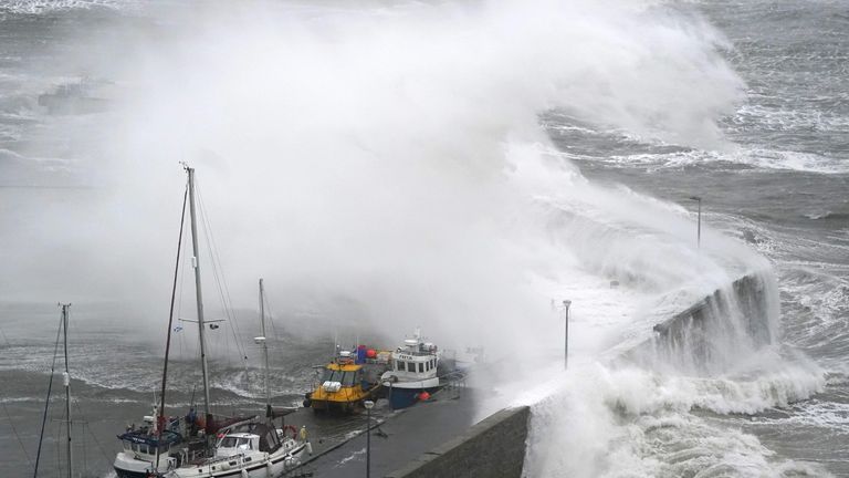
Rescue operations are under way in Brechin
“Torrential and ferocious” conditions have led to “12 hours of destruction”, said Sky’s Scotland correspondent Connor Gillies.
Flood defences of the River Esk in Brechin have been “completely and utterly submerged”, he said.
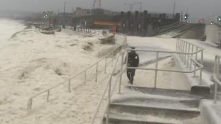
Storm Babet causes sea of foam
The warnings have “come to fruition” and “lives are at risk still” for several more hours, said Gillies.
“Many people will now be picking up the pieces after a really dangerous set of circumstances,” he said.
Traffic Scotland said several sections of major Scottish roads are closed too, including the A85 at Huntingtower near Perth and A90 between Myrekirk and Swallow Roundabouts due to flooding.
Aberdeenshire Council said supplies of sandbags had been “depleted” and would not be replenished. It urged residents not to travel unless it was “absolutely essential”.
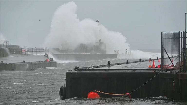
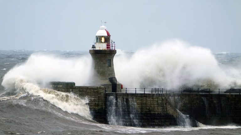
Babet: Waves batter lighthouse
‘Extraordinary’ weather event
More disruption is expected elsewhere across the UK, with amber warnings for wind and rain issued for parts of northern England, the Midlands and northern Wales from noon on Friday to 6am on Saturday.
The Environment Agency has issued 42 flood warnings – in areas where flooding is expected – and 142 flood alerts, where flooding is possible.
Heron Rise in Dundee
Yellow and amber wind warnings have been issued for eastern parts of Scotland and along the east coast of England until the weekend, the Met Office said.
Gusts in excess of 60mph are likely on Friday, with particularly poor conditions on immediate coastlines with large waves adding to the list of hazards.
In the north east of England, South Shields Lighthouse lost its dome in the storm, as huge waves battered the structure.
This image shows South Shields lighthouse before it lost its dome in the storm – and the photo below shows the impact of the waves
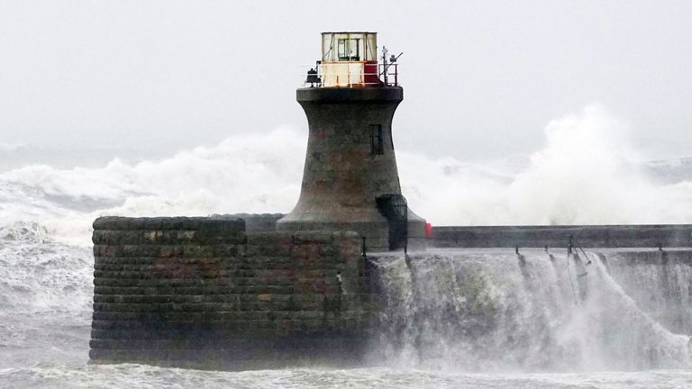
The Port of Tyne authority said with the ongoing dangerous sea conditions, it was not safe to assess the damage to the lighthouse.
People have been urged to steer clear of the area, particularly the piers.
No traffic is going in and out of the river with six metres of sea swell, officials added.
Flooding has also blocked several rail lines across northern England, the Midlands and north Wales.
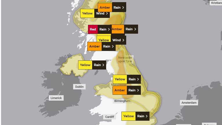
Red, amber and yellow weather warnings are in place for rain and wind. Pic: Met Office
Read more UK news:
‘Political earthquake’ after double by-election result
Police blitz on county lines drug dealers
A yellow warning for Northern Ireland is also in place from 3am on Friday to 9am on Saturday.
Members of the Irish Defence Forces were deployed in the town of Midleton, Co Cork, in the south of Ireland, where more than 100 properties were flooded.
Cork County Council said more than a month’s worth of rain had fallen in the space of 24 hours, leading to unprecedented flooding, saturated land and high river levels across the county.
The storm is an “extraordinary” weather event created by a number of interacting conditions, said Hannah Cloke, professor of hydrology at the University of Reading.
The jet stream has been squeezed into a “weird position”, partly due to a typhoon that hit Japan last week, she said.


Storm Bram has been named by the Irish weather service – with warnings for strong winds and heavy rain issued for parts of the UK and Ireland.
More than half a month’s rainfall could hit some parts of the UK in just a 24-hour period, the Met Office has warned.
Parts of Scotland are also facing a “danger to life” warning due to the “very strong” winds on Tuesday.
Yellow and orange warnings are in place across Ireland today and tomorrow, with “very strong to gale force” winds forecast on Tuesday.
Check the forecast for your area
The Met Office said strong winds forecast from Monday evening through until Wednesday could cause disruption, with gusts of 50-60mph predicted widely and 70-80mph in some places.
A yellow weather warning for rain comes into force from 6pm on Monday, and will be in place until 2pm on Tuesday, covering parts of southwest England and Wales, and stretching to parts of Herefordshire and Hampshire.
The Met Office has also issued a yellow warning for high winds from Dorset to Cornwall and up to north Wales, in place from 10pm on Monday until 4pm on Tuesday.
It said transport networks could face disruption, with delays for high-sided vehicles on exposed routes and bridges, and coastal roads and seafronts affected by spray and large waves. Power outages are also possible.
For 24 hours from 6pm on Monday, up to 40mm of rain could fall in some areas, with 60-80mm of rain over Dartmoor and high ground in South Wales, which would amount to more than half the average monthly rainfall in December.
The predicted rainfall across southwest England and South Wales is expected to hit already saturated ground and could lead to difficult travel conditions.
An amber warning for wind has been issued for northwest Scotland on Tuesday, from 4pm until the end of the day.
Flying debris “could result in a danger to life” – and there could be damage to buildings and homes along with the risk of roofs being “blown off” due to the “very strong and disruptive winds”, the Met Office warned.
Forecasters added there was the potential for large waves and beach material “being thrown” across sea fronts, roads and properties.
There are also further yellow warnings for wind and rain on Tuesday across Northern Ireland, Scotland, Wales and northern England.
Weather warnings issued for Tuesday. Pic: Met Office
Yellow warnings for wind have been issued for Scotland and parts of northern England on Wednesday.
The Met Office’s deputy chief meteorologist, Steven Keates, said: “A deepening area of low pressure will approach the UK from the southwest later on Monday, bringing with it heavy rain and strong winds, which are likely to affect the UK between late Monday and early Wednesday.
“The exact track, depth and timings of this low are uncertain, which makes it harder to determine where will be most impacted by strong winds and/or heavy rain.
“This system has the potential to cause disruption, and severe weather warnings are likely to be issued over the weekend as details become clearer. We therefore urge people to keep up-to-date with the latest Met Office forecast.”
Read more from Sky News:
City may have to evacuate as water supplies run low
UK unveils undersea military technology
Sky News meteorologist Dr Christopher England warned many areas could face disruption from “damaging gusts”.
“There could also be ferry disruption and that even outside the warning areas, potentially damaging gusts of over 50mph are possible,” he said.
“It only takes one tree falling in the wrong place at the wrong time to have a significant impact.”
The Met Office said the rest of the month remained unsettled, with further periods of low pressure predicted.
It said it is too early to provide an accurate forecast for the Christmas period.


-
 Sports2 years ago
Story injured on diving stop, exits Red Sox game
-
 Sports3 years ago
‘Storybook stuff’: Inside the night Bryce Harper sent the Phillies to the World Series
-
 Sports2 years ago
Game 1 of WS least-watched in recorded history
-
 Sports3 years ago
Button battles heat exhaustion in NASCAR debut
-
 Sports3 years ago
MLB Rank 2023: Ranking baseball’s top 100 players
-
Sports4 years ago
Team Europe easily wins 4th straight Laver Cup
-
 Environment3 years ago
Japan and South Korea have a lot at stake in a free and open South China Sea
-
 Environment1 year ago
Here are the best electric bikes you can buy at every price level in October 2024