

Israel said Gazans could flee to this neighbourhood – then it was hit
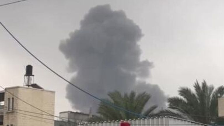
As smoke rose into the overcast skies of Deir al Balah in Central Gaza on 5 December, the whine of an aircraft could still be heard overhead.
The Musabeh family’s home had been destroyed.
Footage of smoke plume from the blast at the Musabeh home in Deir al Balah, Gaza Strip, 5 December 2023
“The scene was horrific, fires burning in the house,” eyewitness Mohammed Abu Musabeh told Erem News, a UAE-based news organisation.
Among the survivors was an infant girl, Layan, a relative of Mr Abu Musabeh, who said she was blown onto a neighbour’s roof by the force of the explosion.
“How will this child continue her life after learning what happened to her family?”
Days earlier on 1 December, a temporary ceasefire had collapsed. In preparation for an invasion of southern Gaza, Israel published an interactive map which divided the territory into hundreds of small zones.
The map, Israel said, would be used to give clear and precise evacuation orders to try to keep civilians in the densely populated Gaza Strip away from active combat zones.
Using on-the-ground footage, satellite imagery and mapping software, a Sky News visual investigation found that Israel’s evacuation orders have instead been chaotic and contradictory and that a neighbourhood in Deir al Balah was hit one day after the IDF said evacuees could flee there.
Our investigation comes after a separate strike in Gaza was caught on camera by a Sky News team. It too came in an area that was supposed to be safe.
‘No safe place in Gaza’
Responding to a request for comment on our findings, the Israeli army did not deny striking the Musabeh home.
A spokesperson for the IDF said: “The IDF will act against Hamas wherever it operates, with full commitment to international law, while distinguishing between terrorists and civilians, and taking all feasible precautions to minimise harm to civilians.”
In response to our investigation, the United Nations told Sky News that it is already investigating 52 similar incidents in areas where the Israeli army told civilians it was safe to evacuate to.
“This is exactly why we as the UN have been saying that there is no safe place in Gaza,” Ajith Sunghay, head of the Office of the UN High Commissioner for Human Rights in the occupied Palestinian territories, told Sky News.
Chaotic orders
After the temporary ceasefire, Israel faced growing international pressure to limit civilian harm.
The IDF’s solution? The interactive map with each zone having a unique numeric ID.
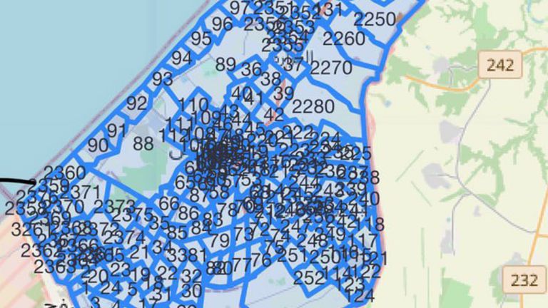
An image of the interactive map was then posted on the Israeli army’s website. Pic: IDF
On 4 December, IDF spokesman Daniel Hagari told journalists that the map would indicate “where civilians in a specific area should go to avoid being in the crossfire”.
Civilians were told to learn the number assigned to their neighbourhood and listen out for evacuation orders via social media.
Questions were immediately raised about how Gazans, who have suffered persistent internet outages, would access the online map, and how they could safely move between areas as instructed.
The UN has not officially recommended that Gazans relocate to areas suggested by the IDF, as the zones have not been agreed with all parties to the conflict.
“One of the fundamental requirements of a safe zone is that all parties agree to a particular place to be safe,” said Mr Sunghay.
On 1 December, the day hostilities resumed, the Israeli army began releasing evacuation orders.
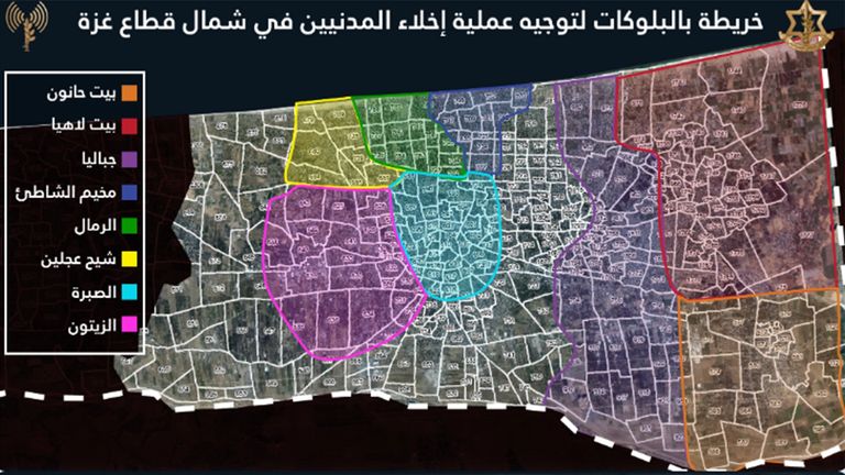
The deleted static map was the first grid map published by the Israeli army. Pic: IDF
Musabeh home hit
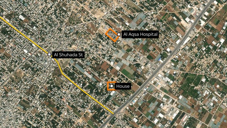
The Musabeh family’s neighbourhood is located in section 128 on Israel’s interactive map. It was never included in any of the IDFs evacuation orders issued on social media.
On 4 December, the IDF’s Arabic-language spokesperson said on X the IDF would allow “humanitarian movement of civilians” along the coastal road from Khan Younis to Deir al Balah.
The Musabeh home lay in the heart of Deir al Balah, less than 300 metres from Shuhada street – a road explicitly marked by the Israeli army as a route by which civilians could safely reach the city.
The day after that post, on 5 December, the Musabeh home was hit.
Pic: Planet Labs PBC
‘I don’t know what happened to my son’
A neighbour said that their son had gone to the Musabeh home to ask for water.
“Then the airstrike happened,” the neighbour told al-Araby. “The dust came at us and cars were thrown into the air. […] I don’t know what has happened to my son.”
The footage below, captured by Gaza-based journalist Yosef al-Saifi, shows the immediate aftermath: a woman and two children calling for help on top of the ruined home, a street covered in rubble, and a car on fire.
One man runs with a young girl in his arms, her body limp and her arms badly burnt. Another man pulls a motionless boy from beneath the rubble.
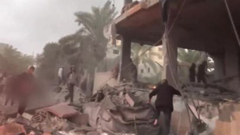
The aftermath of the blast at the Musabeh home in Deir al Balah, Gaza Strip, 5 December 2023
The video below, also recorded by Mr al-Saifi, shows another casualty being carried, also seemingly unresponsive. A fourth casualty is placed on a blood-soaked stretcher, as firefighters tackle a blaze.
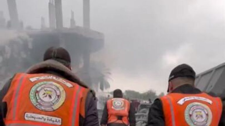
A casualty is carried on a stretcher following a blast at the Musabeh home in Deir al Balah, Gaza Strip, 5 December 2023
Footage of the incident verified by Sky News, including some which is too graphic to publish, shows 11 casualties in total – nine of them apparently unresponsive, including three children.
The spokesman for al Aqsa hospital told Al Jazeera Mubasher that 45 people were killed in the blast. Sky News has been unable to independently verify the exact number of those killed.
Preliminary research carried out by Airwars, an organisation specialising in the verification of airstrike casualties, found online tributes to one of those killed in the attack, Mohammad Kamal Abu Musabeh and further posts about the injured infant Layan. Information online surrounding the identity of those killed has been scarce.
A neighbour of the Musabehs told al Araby that the home had been housing between 70 and 80 people, many of them displaced from elsewhere in the Gaza Strip.
Damage seen in satellite imagery
The neighbour attributed the bombing to an Israeli aircraft, as did a report by Palestinian news agency Wafa.
Eyewitnesses reported a single explosion, and footage verified by Sky News shows that the damage was extensive. The upper floor of the building had collapsed, and its walls were blown out onto the street below.
Visible damage to the Musabeh home can also be seen in satellite imagery taken on 3 December and 6 December.
No remnants of munitions were available for Sky News to conclusively determine whether the IDF was responsible for the attack.
Two experts told Sky News that, based on the footage available, the damage was consistent with an airstrike.
“It was a large [explosion] to have caused that much damage,” says Mark Cancian, a senior adviser at the Centre for Strategic and International Studies.
“It was not an errant rocket or artillery shell. It would be consistent with a large air-delivered munition.”
J Andres Gannon, an assistant professor at Vanderbilt University, agrees.
“Based on the footage provided, the damage seen is consistent with what we would see from a missile strike with a fairly high payload,” he says.
“There is not much burn damage aside from light metal like the vehicles, and much of the rubble is very large pieces of concrete which is different from the smaller fragments we would see from shrapnel damage caused by mortars or other light projectiles.
“Satellite footage shows damage limited to a particular quadrant of the building which suggests more accurate targeting than we would see from a bomb, so that is also consistent with the damage we would see from an air to surface missile.”
Mr Gannon says that the level of damage seen was “quite a bit higher” than could be achieved by the kind of rockets known to be used by Palestinian militant groups in Gaza.
“There is also very little shrapnel or fire damage from spent fuel that I can see, both of which would be present at the site of a smaller rocket or mortar attack,” he added.
Sky News has not seen reports of rockets being fired by any other groups in the area. The IDF later said it had, on that day, launched airstrikes “in the area of Deir al Balah”.
“During these strikes, terrorists from the Hamas and Palestinian Islamic Jihad terrorist organisations were eliminated, and a number of terrorist infrastructure were destroyed,” the post on Telegram on 6 December said.
Sky News presented the findings of this investigation to the IDF. A spokesperson declined to say whether Israel was responsible for the blast at the Musabeh family home.
‘I can’t find any rationale’
Mr Sunghay, the senior UN official, told Sky News that even if only military targets had been struck, there would still be serious questions over the IDF’s decision to tell civilians they could move to Deir al Balah on the day of, and in the days following, the strikes.
“I can’t find any rationale, to be honest,” he said.
“At a minimum you wouldn’t again reiterate that it’s a safe place. If you call it a safe place and people have gone there and you’ve struck it once, at a minimum you would wait a little while. For me, it doesn’t make sense that they kept calling it a safe zone.”
‘Warnings are not enough’
Brian Finucane, an expert legal adviser with the non-profit International Crisis Group, says that there is a requirement on warring parties to provide effective advanced warnings to civilians, where feasible.
“This calls into question whether Israel is actually taking feasible precautions,” said Mr Finucane.
“If [Israel] issues warnings urging people to relocate to a certain area and then nonetheless conducts further strikes there, that’s not really an effective advanced warning.
“But even if this warning scheme worked as advertised… Warnings are not enough. Israel still has to distinguish between civilians and combatants.”
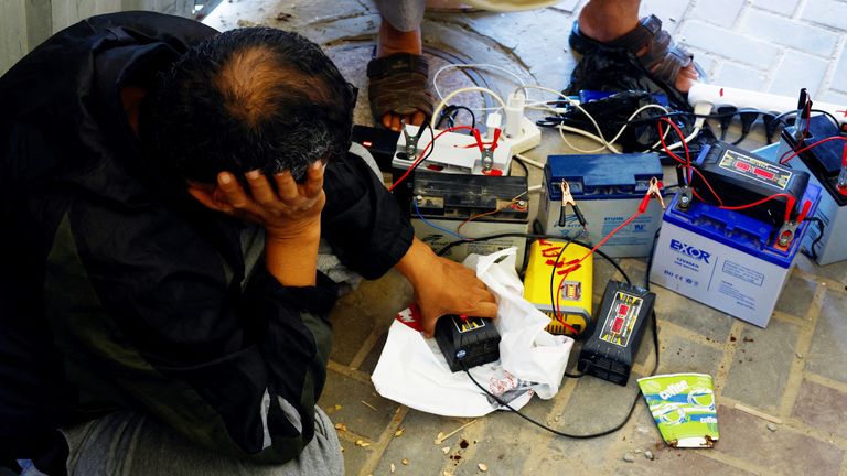
Palestinians charge their mobile phones from a point powered by solar panels in Khan Younis
Even receiving those warnings has been difficult. Intermittent internet and telecommunications outages have made it much harder for civilians across Gaza to find and share information about safe areas.
On 17 December, connectivity was gradually restored after a three-day blackout, the longest outage on record since the start of the present conflict, according to cybersecurity watchdog NetBlocks.
But not all Gazans have mobile devices, making access to the IDF instructions impossible for many. Many people are having to communicate and share information by word of mouth.
And even for those who do have access to phones, Israel’s official social media posts and evacuation orders have been confusing and contradictory.
Sky News analysis of the IDF’s 22 evacuation orders between 1 December and 19 December shows that only nine have included maps of the area to be evacuated. In all nine cases, these maps have directly contradicted the written orders provided.
In only six of the 22 orders did the IDF cite specific numbered zones. In all six cases, parts of the numbered zones were excluded from the static maps attached to the posts.
‘This chaos and confusion could have killed me’
The IDF’s interactive map was presented as a high-tech, humane solution to conducting urban warfare in one of the most densely populated parts of the planet.
Yet this map has never been updated to show areas being evacuated – Gazans have had to rely on static maps published via social media.
None of the evacuation orders have included any mapping of areas to which people can safely flee. Instead, these areas have simply been named.
In the four evacuation orders issued since 16 December, that too has stopped: Gazans have been told where to flee from, but not where they might flee to.
The only safe area which the IDF has mapped is a strip of coastline that Israel has called the al-Mawasi humanitarian zone. It has provided rough sketches of this zone, but has never marked it out clearly. The two maps it has produced are, when analysed in mapping software, contradictory.
Even when the orders are clear, as in the recent orders for civilians to leave the north and head towards Deir al Balah, it is often unclear how Gazans are supposed to safely make the journey.
Kamal Almashharawi, a lawyer from Gaza City who recently fled the territory, recently spoke to a friend in northern Gaza who told him it was too dangerous to even open the curtains due to fighting outside.
Mr Almashharawi was forced to flee the north himself after Israel first ordered its evacuation on 13 October.
“This chaos and confusion could have killed me,” says Mr Almashharawi, who is now in Saudi Arabia.
“I was in Khan Younis at first, and I thought that the ground invasion would start there so I had to go back to Gaza City. We hadn’t heard of any bombing there, we didn’t realise it’s because the internet was cut.”
Mr Almashharawi says that he subsequently arranged an evacuation from Gaza City for himself and around 30 family members.
“On the ‘safe passage’ I saw dead bodies on the ground. Those people read the instructions and followed the instructions, and now they’re dead.”
Mr Sunghay said the UN was planning to publish a report on incidents in areas where the IDF had told civilians to flee to, including Deir al Balah.
“If we are unable to prevent attacks and killings of civilians, what will come next is accountability and for that purpose this work is extremely important,” he said.
A spokesperson for the IDF said: “Since the beginning of the fighting, the IDF has been imploring the civilian population to temporarily evacuate from areas of intense fighting, to safer areas, in order to minimise the risk posed by remaining in areas of intense hostilities.
“The IDF carries out this effort in a variety of ways, including radio broadcasts, a dedicated website in Arabic, millions of pre-recorded phone calls and tens of thousands of live phone calls, and millions of leaflets.
“While the IDF makes these efforts to evacuate the population out of the line of fire, Hamas systematically attempts to prevent the evacuation of civilians by calling on the civilians to ignore the IDF’s requests. In doing so, Hamas endangers the civilian population of Gaza.”
The Data and Forensics team is a multi-skilled unit dedicated to providing transparent journalism from Sky News. We gather, analyse and visualise data to tell data-driven stories. We combine traditional reporting skills with advanced analysis of satellite images, social media and other open source information. Through multimedia storytelling we aim to better explain the world while also showing how our journalism is done.
World
Is this what the beginning of a war looks like? How the US threat around Venezuela is shaping up


Is this what the beginning of a war looks like?
In the deep blue waters of the Caribbean, visible from space, an unremarkable grey smudge.
The USS Gerald R Ford seen off the US Virgin Islands on 1 December. Credit: Copernicus
But this is the USS Gerald R Ford: the largest, most deadly aircraft carrier in the world. And it is only part of an armada, apparently set on Venezuela.

The Gerald R Ford, USS Winston S Churchill, USS Mahan and USS Bainbridge in the Atlantic on 13 November. Source: US Department of Defense
From being able to count on one hand the number of warships and boats in the Caribbean, since August we can see the build-up of the number, and variety of ships under US command.

And that’s only at sea – air power has also been deployed, with bombers flying over the Caribbean, and even along the Venezuelan coast, as recently as this week.

A Boeing B-52H Stratofortress near Venezuelan coast from Minot Air Force Base, North Dakota, on 3 December. Credit: FlightRadar24
Venezuela’s President Nicolas Maduro told crowds his country has endured 22 weeks of aggression from the US and Donald Trump.
Things could be about to get worse.
So let’s rewind those 22 weeks to understand how we got here…
‘Drug boat’ strike
On 2 September, the White House posted on X that it had conducted a strike against so-called “narcoterrorists” shipping fentanyl to the US, without providing direct evidence of the alleged crime.
Sky’s Data & Forensics unit has verified that in the past four months since strikes began, 23 boats have been targeted in 22 strikes, killing 87 people.
Read more: The US-Venezuela crisis explained
The latest was on 4 December, after which US Southern Command announced it had conducted another strike on an alleged drug smuggling boat in the eastern Pacific.
It was the first such strike since 15 November and since the defence secretary, sometimes referred to as secretary of war, Pete Hegseth, came under scrutiny for an alleged “second strike” in an earlier attack.
The US says it carried out the action because of drugs – and there has been some evidence to support its assertion.
The Dominican Republic said it had recovered the contents of one boat hit by a strike – a huge haul of cocaine.
Legal issues
Whatever the cargo, though, there are serious, disputed legal issues.
Firstly, it is contested whether by designating the people on the boats as narcoterrorists, it makes them lawful military targets – or whether the strikes are in fact extra judicial murders of civilians at sea.
And more specifically… well, let’s go back to that very first video, of the very first strike.
What this footage doesn’t show is what came afterwards – an alleged “second strike” that targeted people in the water posing no apparent threat.
That has created a crisis for Hegseth.
Speaking at a cabinet meeting last week, the defence secretary said he did not see that there were survivors in the water when the second strike was ordered and launched in early September, saying that “the thing was on fire”.
And the 4 December strike shows this strategy isn’t over.
The strikes are just part of the story, as warships and planes have headed toward the region in huge numbers.
Drugs or oil?
Some have said this isn’t about drugs at all, but oil.
Venezuela has lots – the world’s largest proven reserves.
Speaking to the faithful on Fox News, Republican congresswoman – and Trump supporter – Maria Salazar said access to Venezuela would be a “field day” for American oil companies.
And Maduro himself has taken up that theme. A few days later, he wrote this letter to OPEC – which represents major oil producing nations – to “address the growing and illegal threats made by the government of the United States against Venezuela”.
That’s how Maduro has framed this – a plan by the US “to seize Venezuela’s vast oil reserves… through lethal military force”.
Lethal military force – an understatement when you think of the armada lying in wait.
And it may be called upon soon. Trump on Tuesday said he’s preparing to take these strikes from international waters on to Venezuelan territory.
Maduro has complained of 22 weeks of “aggression”. There may be many more to come.
Additional reporting by Sophia Massam, junior digital investigations journalist.
The Data X Forensics team is a multi-skilled unit dedicated to providing transparent journalism from Sky News. We gather, analyse and visualise data to tell data-driven stories. We combine traditional reporting skills with advanced analysis of satellite images, social media and other open source information. Through multimedia storytelling we aim to better explain the world while also showing how our journalism is done.


Donald Trump’s bruising assessment of Europe as “weak” and “decaying” is a bitter blow to nations already reeling from the release of his national security strategy.
At the end of the 45-minute interview with Politico, EU leaders might be forgiven for thinking, with friends like these, who needs enemies?
“Europe doesn’t know what to do,” Trump said, “They want to be politically correct, and it makes them weak.”
Trump meets leaders from Ukraine, Germany, France, the UK, Italy, and Finland, as well as the EU and NATO, in August Pic: Reuters
On the contrary, I would imagine some choice words were being uttered in European capitals as they waded through the string of insults.
What has Trump said?
First up, the US president criticised European leaders for failing to end the war between Russia and Ukraine.
“They talk but they don’t produce. And the war just keeps going on and on,” he said.
The fact that the Russians have shown no real commitment to stopping the invasion they started is not mentioned.
Instead, the blame is laid squarely at the feet of Ukraine and its allies in Europe.
“I think if I weren’t president, we would have had World War III,” Trump suggested, while concluding that Moscow is in the stronger position.

Trump meeting European leaders in the Oval Office in August. Pic: @RapidResponse47
Does he have a point?
Critics claim that the White House has emboldened the Kremlin and brought Putin in from the cold with a summit and photo opportunities.
Trump highlights the fact that his return to office forced many European NATO members to increase defence spending drastically.
On this, he is correct – the growing insecurity around how long America can be relied on has brought security into sharp focus.
But the release of the new US national security strategy has only added to the feelings of unease.
German Chancellor Friedrich Merz on Tuesday claimed some of its contents were unacceptable from a European point of view.
“I see no need for America to want to save democracy in Europe. If it was necessary to save it, we would manage it on our own,” he told a news conference in Rhineland-Palatinate, the German state where Trump’s paternal grandfather was born.

Meeting between, left to right, Keir Starmer of the UK, Volodymyr Zelenskyy of Ukraine, Emmanuel Macron of France, Donald Tusk of Poland, and Friedrich Merz of Germany. Pic: AP
The leader of the EU’s biggest power also said the new US strategy was not a surprise and largely chimed with the vice president’s speech at the Munich Security Conference in February.
For this reason, Merz reiterated that Europe and Germany must become more independent of America for their security policies.
However, he noted, “I say in my discussions with the Americans, ‘America first’ is fine, but America alone cannot be in your interests.”
For his part, while Trump said he liked most of Europe’s current leaders, he warned they were “destroying” their countries with their migration policies.
He said: “Europe is a different place, and if it keeps going the way it’s going, Europe will not be…in my opinion, many of those countries will not be viable countries any longer. Their immigration policy is a disaster”.
He added: “Most European nations… they’re decaying.”
Read more:
Analysis: Putin preparing for more war, not less
White House: Europe ‘unrecognisable in 20 years or less’
Again, the comments echoed his security strategy, which warned immigration risked “civilisation erasure” in Europe.
There’s no doubt immigration is a major concern for many of the continent’s leaders and voters.

Zelenskyy meets European leaders
However, irregular crossings into the EU fell 22% in the first 10 months of 2025 according to Frontex, a fact which seems to have passed the president and his team by.
“Within a few decades at the latest, certain Nato members will become majority non-European”, his security document warned.
It also suggested “cultivating resistance” in Europe “to restore former greatness” leading to speculation about how America might intervene in European politics.
Trump appeared to add further clarification on Tuesday, saying while he did not “want to run Europe”, he would consider “endorsing” his preferred candidates in future elections.
👉 Tap to follow Trump100 wherever you get your podcasts👈
This comment will also ruffle feathers on the continent where the European Council President has already warned Trump’s administration against interfering in Europe’s affairs.
“Allies do not threaten to interfere in the domestic political choices of their allies,” Antonio Costa said on Monday.
“The US cannot replace Europe in what its vision is of free expression… Europe must be sovereign.”
So, what will happen now, and how will Europe’s leaders respond?
If you are hoping for a showdown, you will likely be disappointed.
Like him or loathe him, Europe’s leaders need Trump.
They need the might of America and want to try to secure continued support for Ukraine.
While the next few days will be filled with politely scripted statements or rejections of the president’s comments, most of his allies know on this occasion they are probably best to grin and bear it.
World
‘Cheap ceasefire’ between Ukraine and Russia would create ‘expensive peace’ for Europe, Norway’s foreign minister warns


A “cheap ceasefire” between Ukraine and Russia – with Kyiv forced to surrender land – would create an “expensive peace” for the whole of Europe, Norway’s foreign minister has warned.
Espen Barth Eide explained this could mean security challenges for generations, with the continent’s whole future “on the line”.
It was why Ukraine, its European allies and the US should seek to agree a common position when trying to secure a settlement with Vladimir Putin, the top Norwegian diplomat told Sky News in an interview during a visit to London on Tuesday.
Ukraine war latest: Trump says Putin has upper hand in peace talks
“I very much hope that we will have peace in Ukraine and nobody wants that more than the Ukrainians themselves,” Mr Eide said.
“But I am worried that we might push this to what in quotation marks is a ‘cheap ceasefire’, which will lead to a very expensive peace.”
Explaining what he meant, Mr Eide said a post-war era follows every conflict – big or small.
Inside Ukraine’s underground military HQ
How that plays out typically depends upon the conditions under which the fighting stopped.
“If you are not careful, you will lock in certain things that it will be hard to overcome,” he said.
“So if we leave with deep uncertainties, or if we allow a kind of a new Yalta, a new Iron Curtain, to descend on Europe as we come to peace in Ukraine, that’s problematic for the whole of Europe. So our future is very much on the line here.”
He said this mattered most for Ukrainians – but the outcome of the war will also affect the future of his country, the UK and the rest of the continent.
“This has to be taken more seriously… It’s a conflict in Europe, it has global consequences, but it’s fundamentally a war in our continent and the way it’s solved matters to our coming generations,” the Norwegian foreign minister said.
Russia ‘will know very well how to exploit vagueness’
Asked what he meant by a cheap ceasefire, he said: “If Ukraine is forced to give up territory that it currently militarily holds, I think that would be very problematic.
“If restrictions are imposed on future sovereignty. If there’s vagueness on what was actually agreed that can be exploited. I think our Russian neighbours will know very well how to exploit that vagueness in order to keep a small flame burning to annoy us in the future.”
Progress being made on peace talks
Referring to the latest round of peace talks, initiated by Donald Trump, Mr Eide signalled that progress was being made from an initial 28-point peace plan proposed a couple of weeks ago by the United States that favoured Moscow over Kyiv.
That document included a requirement for the Ukrainian side to give up territory it still holds in eastern Ukraine to Russia and Mr Eide described it as “problematic in many aspects”.
But he said: “I think we’ve now had a good conversation between Ukraine, leading European countries and the US on how to adapt and develop that into something which might be a good platform for Ukraine and its allies to go to Russia with.
“We still don’t know the Russian response, but what I do know is the more we are in agreement as the West, the better Ukraine will stand.”
-
 Sports2 years ago
Story injured on diving stop, exits Red Sox game
-
 Sports3 years ago
‘Storybook stuff’: Inside the night Bryce Harper sent the Phillies to the World Series
-
 Sports2 years ago
Game 1 of WS least-watched in recorded history
-
 Sports3 years ago
Button battles heat exhaustion in NASCAR debut
-
 Sports3 years ago
MLB Rank 2023: Ranking baseball’s top 100 players
-
Sports4 years ago
Team Europe easily wins 4th straight Laver Cup
-
 Environment3 years ago
Japan and South Korea have a lot at stake in a free and open South China Sea
-
 Environment1 year ago
Here are the best electric bikes you can buy at every price level in October 2024